I caught the ferry to Anacortes at 4:15PM, and didn’t arrive at my destination until about 5:45. I didn’t have much time to get to my next camp site, so I was going to try to hurry. I was headed to Rosario Bay, where there would be camping. It was about 10 miles from the ferry terminal, and there were also lots of hills like San Juan island. At several points along the ride, I was treated to nice views of a brilliant sunset. I didn’t think Anacortes was going to be that scenic, but it definitely was.


About 2/3rds of the way there, I started feeling weak because of hunger. I had to stop and make a peanut butter banana sandwich, even though it was getting dark in the trees that I was riding through. Riding in the dark makes me nervous because I don’t trust cars when I don’t have much of a shoulder to ride on. At a few points on the ride, there wasn’t but 6 inches of space for me to ride on.

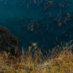
By the time I approached the turnoff to the bay, it was dark and I could barely read the signs. The last stretch involved me riding on a very dark road in the forest with no shoulder and lots of blind curves. I cursed to myself for not getting there faster, worried that a car would come speeding around the corner to hit me, I pedaled as fast as I could up the last hill. Finally, I saw a turnoff that looked like the right one for Rosario Bay. I was off the main road and sighed in sweaty relief. I cruised down the hill and when I got to the bay, I was awestruck by the last few minutes of the dusk sunset. I took many photos without the aid of a tripod, hoping to get at least one that wasn’t blurry. I did get one, and it turned out gorgeous. Definitely one of my favorite photos yet.

After my little photo shoot, I decided to get my headlamp on and start looking for a place to pitch a tent. I saw a trail that led uphill that looked promising, so I parked my bike and ventured up the hill. To my surprise, the trail opened up to a panoramic view of the ocean. it was beautiful, and I immediately knew I wanted to camp here. So I ran back down the hill to get my bike. I knew it was going to be tough to push my load back up that steep trail, but it would be worth it to camp on another lookout point. I pitched my tent and got to making a pot of quinoa and beans for dinner. After dinner, I was too eager to look at my recently acquired photos, so I took out my laptop and pulled them off the memory card. One nice thing about carrying the laptop with me on this trip is being able to sort and edit photos along the way, rather than having to buy a bunch of memory cards and save all the editing for when I got home. That would seem like a lot of work, but bit by bit, it’s a lot of fun.
The next morning, I woke up at 7:30. I got out of my tent and was awestruck at yet another beautiful series of sunrise vistas. Sorry if the sunrise/sunset photos get old, they never do for me, so take a look at these:


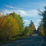
After taking photos, I followed my usual routine of oatmeal and coffee. By 10am I was packed up and ready to go. I rolled my bike down the trail, down the hill I came up the night before. I took one last look at the scenery and headed out. My next destination was to Port Townsend, where I would camp at Old Fort Townsend state park. After a few miles of climbing, I was at the Deception Pass bridge, which is a huge bridge without much of a shoulder or bike path on it. The scenery from on top of the bridge is pretty gorgeous, but the photos I took didn’t turn out all that amazing.

My first instinct for getting across was to take the pedestrian path on the side. A minute later, I realized it was almost too narrow, but I didn’t have room to turn around, so I kept going, trying not to tear holes in my panniers from the concrete walls. Halfway across, there was a couple who were taking photos. I asked if I could scoot by them. They barely could squeeze in between my bike and the wall. Another few minutes of careful riding and I was back on the road. The rest of the ride was fairly uneventful, just a good amount of climbing as per usual. It passed through Oak Harbor, where I stopped to pick up lunch and more peanut butter. There wasn’t a whole lot of choices for lunch, and the hot food at Safeway looked good because I was hungry. I got fried chicken wing and a chimichanga. Later I would regret eating that, because it sapped my energy, and I just didn’t feel very good. When I got to the Keystone ferry, I was happy to rest and wait in the sunshine by the sea. Twenty minutes passed, and the ferry arrived. On deck, I decided I needed to true my back wheel because it was getting wobbly again. It seemed that the rest of the trip would require constant attention to my back wheel ever since I broke a spoke back in Victoria. Every 30 miles or so, it would go back out of true and I’d have to fix it again. I hoped I would be able to make it to Portland without the wheel completely breaking on me.
Once I got to Port Townsend, I headed out of my way towards Fort Worden state park because they had hot showers, which was really tempting. I hadn’t had a shower in days and was sure I needed it badly. For a dollar, I got about 4 minutes in the shower. I was able to wash my shirt and underwear, which I would strap to the back of my luggage to dry for the rest of the day. Back on track, I headed to my final destination. After several wrong detours (I blame trying to follow google maps for shortcuts), I finally got to the park after a long downhill descent. When I arrived, I saw a sign that said: “Park Closed”. Damn. I was too tired to try to camp anywhere else for the night, so I decided to camp there anyway. I hoped the water was still turned on, because I was out of water and needed some to cook dinner. Luckily, everything was still functional, including water, toilets, and electricity. I found a covered picnic table shelter and set all my stuff down. It began to rain, and I was thankful to have the shelter with a light and a place to recharge my GPS and phone. I called Shannon from skype with my phone and we talked for hours. It was nice to catch up with her after few days of talking to only myself. I told her I was a little apprehensive about my next day’s trip, it was 64 miles and lots of big hills, including a pass over Mt. Walker. I wasn’t sure if I’d be able to make it because I had only biked 30 miles that day, and was completely exhausted. I think the crappy lunch might have had something to do with that, though.
As night fell, I decided that I wanted to get an early start the next day, so I skipped setting up my tent. I just put my air mattress on the picnic table and slept under that shelter for the night. I was happy that no forest ranger came and told me to leave the whole time. I don’t think anybody even knew I was there.
The next day, I left my camp site at about 9 AM. I was in for a big ride that day, but I was prepared for it.
I had a hearty breakfast with some coffee and started my ascent back up Old Fort Townsend road to highway 20 south. After several miles of pedaling alongside cars, which I didn’t really enjoy that much, the highway joined with highway 101. After an hour of biking, I realized that my front derailleur needed adjusting: I couldn’t switch into my lowest gear, which I would need for that day of climbing up Mt. Walker. I pulled into a gravel lot to attempt to adjust it, even though I had never done that before. I whipped out my phone, and opened up this app called “Bike Doctor”, which gave step-by-step directions on how to perform many essential bike repairs. Then I learned how to adjust the height and angle of the front derailleur, as well as turning the limit screws to adjust the limits of how far the derailleur could go. For some reason, I couldn’t get it adjusted right, and spent an hour and a half trying to get it right. Realizing I was wasting precious time, I decided to call it quits and just deal with not being able to shift into my lowest gear.
After passing the small town of Quilcene, the real climb began. Luckily, I was able to manually push the derailleur far enough to the left to shift into the low gear. I would just have to keep it in a low gear the whole climb. It ended up taking about 45 minutes to ascend, which wasn’t that bad. I had my headphones playing some music to keep me going. The descent was the best part: miles of downhill, not much pedaling necessary. It was a good break and the wind felt great after the sweaty climb.
The rest of the day, I navigated winding shoulderless roads, which passed by a few scenic areas. I stopped for misc. supplies at little grocery stores, and mostly enjoyed the rest of the ride.


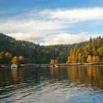
About 10 miles before my destination, I had already pedaled 54 miles. Suddenly my butt began to hurt, because I made the mistake of wearing underwear with my bike shorts. I had an epic wedgie and the friction was hurting. I kept going anyway, determined to make it the 60 miles. I pedaled through the pain, and just kept going and going. It seemed never ending. But finally, somehow, I made it to Potlatch state park. I wasn’t too exhausted to walk around the park a little and take some photos, however.

I was happy to find that the campground had hot showers, and gladly payed the dollar for a hot shower to wash my shirt again and feel clean and fresh.
After my shower, I checked the weather on my phone and realized it was going to be raining for the next 3-4 days, at least. Realizing that my wheel was on the verge of breaking more spokes with a bad wobble, I decided I would ride another 39 miles to Olympia and take the train to Portland from there.
The next day, it was raining buckets, and I decided to stay in the tent for a few hours and wait it out. I actually considered taking the day off, but got bored after a while and decided to leave. The rain stopped for a little while before I left, and I quickly shed all my rain gear because it was getting hot underneath it all. I realized I much prefer just a pair of bike shorts getting wet rather than pants with rain pants over them. That just gets too sweaty.
15 miles later, I arrived in Shelton. Because I was still a little sore from the previous day, and my train didn’t leave until the next day, I decided to treat myself to a hotel room at the Shelton Super 8. It ended up being way more than I would have liked to pay (keep in mind, my being accustomed to hostel prices or free camping), but I said, what the hell, and just dried out all my gear, and enjoyed having two queen beds and a desk to work at all night.
For dinner, I had been craving mexican food, so I went to this place called El Sarape, which was overpriced, but decent enough. I got a chimichanga and lots of chips ‘n salsa. I went to bed satisfied, and woke up first thing in the morning. I got their free continental breakfast (english muffins with butter…. oh how I missed butter…. a few bananas and hard boiled eggs) then began my ride. After 6 miles over a few steep hills, I got a call from the hotel. I had left my daypack with my flute in it. “Goddamnit” I thought to myself. I had to turn back and get it. That tacked on 12 miles I hadn’t planned on for the day. So the total would be 42 miles for the day rather than 30. Oh well, that was totally doable. I just always go back to thinking “I’ll be in better shape for it” when I think about the work it takes to haul 70 pounds up those hills. When I was about halfway to Olympia, my wobbly wheel started rubbing against the brake pad, and it was seriously slowing me down. I decided to stop at one of the exits off the highway to do a quick truing. To my chagrin, another two spokes had broken. Not wanting to break even more and set off a chain reaction of broken spokes while I was flying down a hill at 30 miles per hour, I decided it would probably be safer to hitch a ride the rest of the way to the train station. It was worth a shot, anyway. The first big truck I saw, I asked if they were going to Olympia. Of course they weren’t, they weren’t going onto the onramp headed east. The next time, I waited until I saw a truck headed in that direction. There was one guy about my age driving a huge truck all by himself, with plenty of room in the back. I asked if he was headed to Olympia. Sure enough, he was, he said “hop on in”. My first hitchhiking experience of the whole trip turned out pretty well. I thanked him and loaded my bike up onto the truck bed. During the 20 minutes of driving through pouring rain, we chatted about random little things. I asked where he grew up, he said Steamboat island, where there were 50 houses all packed together really closely. I remarked about how he probably knew his neighbors pretty well. He chuckled. His name was Eli, he was the son of a wood mill operator. I joked about how awful the paper mills smelled. He said the worst one he has ever smelled was in Camas. I tried to give him some gas money and he refused, saying he was going to be in the area anyway. I was thankful for the ride. Since I arrived at the train station much earlier than expected, I was able to get the 1PM train instead of the 7PM train. That saved me many boring hours waiting at this teeny Amtrak station. On the way back on the train, I watched a movie, “127 hours,” which I had avoided watching until then because I couldn’t bear the thought of watching some guy cut his own arm off. As I expected, that scene was almost unbearable to watch. I’m sure people across from me were wondering why I was cringing and putting my hands up to my face in gestures of pain. Overall though, the movie reminded me of how we should always live like we might die tomorrow. Things like remembering to tell your family and loved ones how much you really appreciate them, or going out and doing the things you always wished you had the time to do. If we really lived like today was our last day on earth, how would our actions differ from our normal, habituated life?
Arriving back in Portland was a little surreal. I walked my bike from the train station to my friends Chris and Natalie’s apartment, which is conveniently close downtown. I passed by my old office at Jama, reliving the memories of biking to work up Hoyt street every day. I had gotten to know this part of town really well that year, so it was kind of a trip back down memory lane. Everything still seemed the same as before I had left. Not much changed. Arriving at the apartment, I knocked on the door and was happy to see Natalie again. I thanked her profusely for letting me borrow her Canon D70 camera for 2 months. It was so important for me to be able to share the remarkable beauty of the landscapes I had visited with a nice camera. I can’t believe I actually considered not taking a camera because I could just my iPhone’s poor quality camera.
I must have been talking a mile a minute about all the stories from the past two months, I had so much to share. When Chris got home a few hours later, I gave them a photo slideshow. They told me how awesome the photos were, and how they wanted to use them for desktop wallpapers for their computers. That gave me an idea. What if I put up a collection of full-resolution images for people to download? And what if I asked for a pay-what-you-want donation to fund the purchase of my own digital SLR camera so I can continue taking photos of beautiful landscapes? Realizing that I have a really nice selection of wallpapers on my hands now, I have yet to decide what to do with them. I think I might just do the donation-based download of photos. Thoughts? Leave them in the comments below.
Cameron – I am interested in using one of your pictures on my website, which I saw on the stocxching website. Please let me know if this is possible.