After I left Shannon’s apartment complex, I caught the sky train to the bus that would take me to the ferry terminal. I was originally planning to go from Victoria to Port Angeles. But, after purchasing “Bicycling the Pacific Coast” on my kindle and reading through it a bit, I realized that it would probably be wise to follow the directions from the book. Their recommended route was from Sidney to San Juan and Orcas island, to Anacortes, WA. At first, I had thought that I had seen a few of the islands in BC, so I had seen them all. But, then I was thinking, well, I haven’t seen any of the islands on the American side, so I’ll check out San Juan island. After all, most people I know in Portland have been there, so I figured I should check it out while I was in the area. When I got to Sidney, I realized that I had already missed the one ferry of the day, so I’d have to wait till the next day. Luckily there was a camp site nearby, so I decided I would stay there that night. The rest of the day I spent taking photos, hanging out at a coffee shop, and catching up with people online.

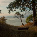
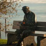
One of the interesting things about Sidney is all the statues of people around the city. They were built by artist Nathan Scott. I really liked the one on the bench by the ocean.
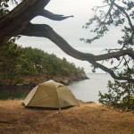
I was glad I wasn’t in a rush. After the sun set, I biked back to the camp site and pitched my tent in the dark. I cooked up an easy dinner of instant corn chowder that I bought in Vancouver, and read for the rest of the night. Sleep was easy, and before I knew it, the sun was streaming through the woods into my tent. It was 7AM. I wanted to get an early start on the day, so I jumped out of my tent and made some oatmeal. Making breakfast, cleaning dishes, and packing up my camp site took about 1.25 hours. By 8:30, I was out and headed to the beach to enjoy the increasingly rare sunshine for a bit. I got some great photos of a heron.


About 10 minutes before the ferry departed, I biked to the terminal and entered the small customs building. They asked the usual border-crossing questions, I showed them my passport and boarded the ferry. Instantly, I felt like there was a big difference between BC ferries and the Washington government-run ferries. For one, it felt just like our government — aging towards obsolescence. They must have built this ferry in the 70’s. It had ugly flourescent lights, the chairs and benches seemed like they were straight out of an old high school.

A few things about the ferry put me at unease. Maybe it was the fluorescent lights or all the vending machines. The informational displays in the ferry were about the military history and influence on the ferry. There were signs everywhere saying “Assaults on washington state employees will be prosecuted to the full extent of the law”. I counted at least 5 of these signs. Why did they feel they needed to remind us about law and punishment so frequently? The vending machines had stickers on them saying something like “Healthy choices: All food meets the following nutritional requirements….” Then proceeded to list number of calories, grams of carbohydrates, etc. Of course, the food was all junk. But the fact that they were saying it was healthy was just false advertising. In Canada, I felt like they were more truthful in their public notices and displays, for example, in the sky train terminal, they had posters warning not to overuse antibiotics. Just little things like that made me realize I like certain things about Canada more than the states.
When the ferry pulled into Friday Harbor, I rolled my bike onto land, to be intercepted by a border guard in a uniform that looked made him look like a police officer. He asked me where I was from, how long I’d been in Canada, why I was in Canada, and if I purchased anything. The usual customs procedure. It was actually less of a hassle than I’ve experienced in the past with customs. He let me pass, and I started riding up the hill. This was my first opportunity to follow the directions in “Bicycling the Pacific Coast,” which was on my Kindle. I’m actually really pleased with using the kindle as a cue sheet for cycling, with point-by-point directions from the book. I just put the kindle in my transparent, rain-proof map case on the handlebar bag along with my GPS and I’m able to press the “next page” button through the plastic as I pass each waypoint. The only thing I wasn’t too pleased with was most of the mile marker numbers in the book are incorrect (which, I knew about in advance from the Amazon.com reviews of the book). No matter, I was still able to navigate successfully around the island without using the mile markers. I did end up using a map I got from the info center by the ferry.
Like many of the gulf islands, San Juan island is pretty hilly at times. The total length of the tour around the island was 31.3 miles, which isn’t too bad, but requires a considerable amount of effort once you factor in all the climbs.
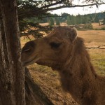
One of the first things I saw was so random… A camel. Who keeps camels in the Pacific Northwest? I saw this camel off in the distance and stopped at the fence to take some photos. Before I knew it, the camel was curious and came right up to me.


Turns out, there is a story behind the camel. I googled “San Juan Island camel” and found this story. Her name is “moanie” because she would make a moaning sound whenever her owner left her side. From the article, it says: “Camels bond very strong with whoever raises them. They’re very tender animals; she loves to kiss”
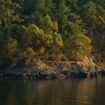
After the random camel, I stopped at various bays and viewpoints. For a snack, I stopped at a viewpoint of Roche Bay, overlooking a harbor filled with yachts and sailboats. I saw some blackberry bushes all around. They weren’t at their peak ripeness, but there were still some good ones left, alongside a lot of moldy ones. I decided to collect as many good ones as I could find and save them for oatmeal the next morning (my new favorite camp breakfast was peanut butter oatmeal with blackberries in it) Afterwards, I decided to head to San Juan county park to set up camp for the evening. I only had a few hours of sunlight left, so I figured I would do the rest of the loop the next day. On the way, I stopped at English Camp, which is a historical site where there was a dispute between the English and the Americans that almost erupted into war.

The dispute was over the killing of a pig, which ended in a territorial fight ending in the British ceding. The restored buildings were rather plain, rectangular whitewashed wooden structures. It made me think about how the utilitarian style of architecture characterized by western civilization is often so boring and… square. Thinking back to what interested me much more, I remembered the geodesic dome houses on Denman Island. I wanted to learn how to build like that. Forget making square houses.
When I arrived at San Juan county park, I was greeted by a park ranger. I said hello back to him and just rested for a bit on a picnic table, soaking in the view of the bay. The park had good western exposure along the coastline, so I was going to watch the sun set that evening. All of the camp sites were in boring spots, and of course you had to pay for them. I eyed a trail up to an elevated ridge with a coastal bluff viewpoint. Hiking up to the top, I quickly decided I wanted to camp on the edge of the cliff that overlooked the ocean below, as that was my favorite kind of camping spot. I’m not sure if I was supposed to camp there, but I figured it would be alright since I’m a leave-no-trace kind of camper.

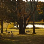
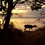
The site was beautiful, and I was just so pleased that I had a sunset to watch as I prepared my dinner. Soon after I set up my tent, I heard a crash in the bushes. Slightly startled, I looked over my shoulder. It was a young deer eating his dinner of grass. I hid behind a tree so he wouldn’t see me. Slowly, I took my camera out of my bag and decided to stalk the deer to get some good sunset deer photos. I needed to move to a better spot, so that I could get a silhouette shot rather than a dark blurry image of the deer in the woods. Slowly, I crept to a better viewpoint. Whenever the deer looked up at me, I froze until he went back to munching grass. Eventually, I was at a good spot for taking photos.

Oh well, it was still a pretty good photo. The second photo I got was when I moved to a different viewpoint, and the deer poked his head above a ridge just in time for me to snap one more photo.

Then I tried to get closer, and he ran away. I ended up getting two decent photos that I was very happy with. After that, I snapped some more photos of the beauty of the coastal sunset.
The next day, I awoke to a bit of rain and clouds, so I slept in. I didn’t think anybody would be out on the path early in the morning on a rainy day, so I wasn’t in a rush to pack up my camp site. I ate my blackberry peanut butter oatmeal, thinking to myself that it wasn’t quite as sweet and juicy as last time. Blackberry season was mostly over. It was still good though. The rest of the ride back to Friday Harbor was pretty uneventful. Just lots more big hills to climb, this time I was more sore than the day before. Oddly enough, the most sore part of me were my pectoral muscles from tensing them while I pulled on the handlebars.
Back at the harbor, I got some coffee and wifi to catch up on e-mails and write a little bit while I waited for the ferry that would take me on to my next destination, Anacortes.